Skip to main content
Site maintenance in progress — some items may not be available
Wyld, James, 1790-1836
Close
Refine Results
Show Only Public Domain
Format
Map
(3)
Date
to
Names
James Wyld
(3)
Wyld, James, 1790-1836
(3)
Department
Baldwin Collection of Canadiana
(3)
Country
Canada
(2)
United States
(2)
Historical location
Upper Canada
(2)
Medium
Regional maps
(3)
Province state
Ontario
(2)
Québec
(2)
New York
(1)
Sort:
Title (A–Z)
Date (Older First)
Date (Newer First)
Title (Z–A)
Last Updated (Ascending)
Last Updated (Descending)
List
Images
Table
/ 1
Filters
3 results
Map of the Oregon Districts and the adjacent country
James Wyld
1843
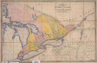
A map of the province of Upper Canada describing all the new settlements and townships &c. with the countries adjacent from Quebec to Lake Huron
Wyld, James, 1790-1836
1838
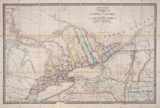
A map of the province of Upper Canada describing all the settlements and townships &c. with the countries adjacent from Quebec to Lake Huron
Wyld, James, 1790-1836
Approximately 1872
/ 1
RDF
XML
JSON