Skip to main content
Wadsworth & Unwin
Close
Refine Results
Show Only Public Domain
Format
Map
(5)
Date
to
Names
Wadsworth & Unwin
(5)
Alexander & Cable Lithographing Co. Ltd
(1)
City of Toronto
(1)
Burland-Desbarats Lithograpic and Pub. Co.
(1)
Denison, George T. (George Taylor), 1839-1925
(1)
Copp Clark Company
(1)
G.N. Tackabury
(1)
Rolph, Smith & Co.
(1)
Collection
Baldwin Collection of Canadiana
(5)
City, town, township
Toronto
(4)
Neighbourhood
Junction
(1)
Kensington-Grange
(1)
Parkdale
(1)
Sort:
Title (A–Z)
Date (Older First)
Date (Newer First)
Title (Z–A)
Last Updated (Ascending)
Last Updated (Descending)
List
Images
Table
/ 1
Filters
5 results
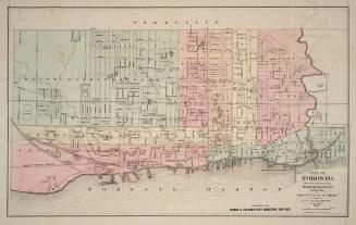
City of Toronto, reduced by permission from Wadsworth & Unwin's large map for Tackabury's Atlas of the Dominion
Burland-Desbarats Lithograpic and Pub. Co.
1875
Plan of building lots for sale, the property of the corporation of the City of Toronto, situate in St. Patrick's ward, City of Toronto
Copp Clark Company
1872
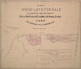
Plan of wood lots for sale laid out on the north east quarter of lot no. 111 in the 4th con. west of Yonge Street, York the property of G.T. Denison Esq.re.
Wadsworth & Unwin
1868
Runnymede Estate; a subdivision of the westerly parts of lots 39 and 40, con. 2 from the bay, township of York
Alexander & Cable Lithographing Co. Ltd
1884
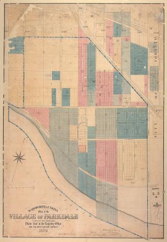
Wadsworth & Unwin's map of the village of Parkdale compiled and drawn from plans filed in the registry office and the most recent surveys
Rolph, Smith & Co.
1879
/ 1
RDF
XML
JSON