Skip to main content
Faden, William, 1750-1836
Close
Refine Results
Show Only Public Domain
Format
Map
(3)
Picture
(2)
Date
to
Names
Faden, William, 1750-1836
(5)
Bennett, W. J. (William James), 1787-1844
(2)
Bouchette, Joseph, 1774-1841
(2)
Wm. Faden
(2)
Sauthier, Claude Joseph, 1736-1802
(2)
Unknown
(2)
Great Britain. Army
(1)
Ratzer, B.
(1)
Smyth, David William, Sir, 1764-1837
(1)
Collection
Baldwin Collection of Canadiana
(5)
Building Monument Park
Fort Chambly (Chambly, Québec)
(1)
City, town, township
Chambly
(1)
Sort:
Title (A–Z)
Date (Older First)
Date (Newer First)
Title (Z–A)
Last Updated (Ascending)
Last Updated (Descending)
List
Images
Table
/ 1
Filters
5 results
Fort Chambly (Chambly, Québec) and Part of the Great Camp, 1814
Bennett, W. J. (William James), 1787-1844
1815
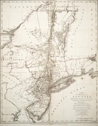
A map of the province of New-York, Reduc'd from the large drawing of that Province, Compiled from Actual Surveys by Order of His Excellency William Tr(...)
Faden, William, 1750-1836
1776
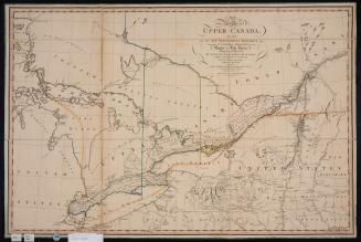
A map of the province of Upper Canada describing all the new settlements and townships &c. with the countries adjacent from Québec to Lake Huron
Smyth, David William, Sir, 1764-1837
12 April 1800
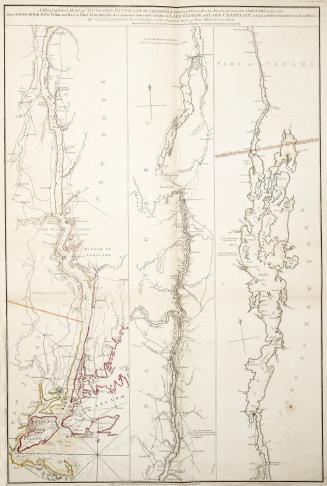
Topographical map of Hudson's River with the Channels depth of Water, Rocks, Shoals etc
Faden, William, 1750-1836
1776
View of the Village of St. Thomas, Riviere du Sud (Montmagny, Québec, 1813-14)
Bennett, W. J. (William James), 1787-1844
1815
/ 1
RDF
XML
JSON