

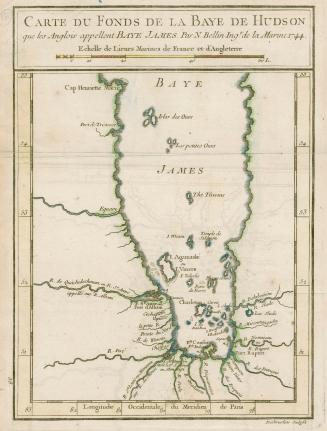
Carte de la baye de Hudson
Date1744
Names
Bellin, Jacques Nicolas, 1703-1772
(cartographer)
Desbruslins, active 18th century
(engraver)
FormatMap
NotesThe map was produced for Charlevoix's 1744 Histoire et description générale de la Nouvelle France.
Subject
Dimensions23 cm x 31 cm (9 1/16 in. x 12 3/16 in.)
Language
ProvenanceFrom the George Weston Limited donation of printed maps and illustrations 2002
CollectionBaldwin Collection of Canadiana
Usage Rights
Public Domain
(Learn More)
Object Number912-19632-B25-WESTON-19
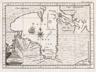
Bacqueville de La Potherie, M. de (Claude-Charles Le Roy), 1668-1738
1722

![Carte de la riviere Longue : et de quelques autres, qui se dechargent dans le grand fleuve de Missisipi [sic] ... ; Carte que les Gnacsitares : ont dessine sur des paux de cerfs ..](/internal/media/dispatcher/2001889/thumbnail)
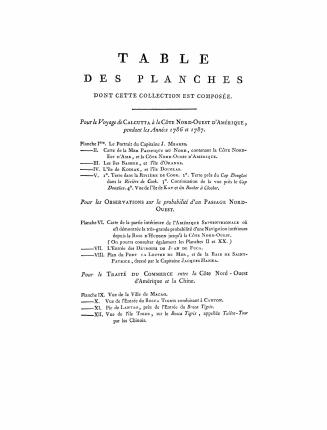
![Voyages de la Chine a la cote nord-ouest d'Amérique: faits dans les années 1788 et 1789; précédés de la relation d'un autre voyage exécuté en 1786 sur le vaisseau le Nootka, parti du Bengale; d'un recueil d'observations sur la probabilité d'un passage nord-ouest; et d'un traité abrégé du commerce entre le côte nord-ouest et la Chine, etc. etc. Par le Capitaine J. Meares, Commandant le Vaisseau la Felice. Traduits de l'anglois par J.B.L.J. Billecocq, citoyen français. Avec une collection de cartes géographiques, vues, marin[es] plans et portraits, gravés en taille-douce](/internal/media/filedispatcher/755967/thumbnail)
![Voyages de la Chine a la cote nord-ouest d'Amérique: faits dans les années 1788 et 1789; précédés de la relation d'un autre voyage exécuté en 1786 sur le vaisseau le Nootka, parti du Bengale; d'un recueil d'observations sur la probabilité d'un passage nord-ouest; et d'un traité abrégé du commerce entre le côte nord-ouest et la Chine, etc. etc. Par le Capitaine J. Meares, Commandant le Vaisseau la Felice. Traduits de l'anglois par J.B.L.J. Billecocq, citoyen français. Avec une collection de cartes géographiques, vues, marin[es] plans et portraits, gravés en taille-douce](/internal/media/filedispatcher/756385/thumbnail)
![Voyages de la Chine a la cote nord-ouest d'Amérique: faits dans les années 1788 et 1789; précédés de la relation d'un autre voyage exécuté en 1786 sur le vaisseau le Nootka, parti du Bengale; d'un recueil d'observations sur la probabilité d'un passage nord-ouest; et d'un traité abrégé du commerce entre le côte nord-ouest et la Chine, etc. etc. Par le Capitaine J. Meares, Commandant le Vaisseau la Felice. Traduits de l'anglois par J.B.L.J. Billecocq, citoyen français. Avec une collection de cartes géographiques, vues, marin[es] plans et portraits, gravés en taille-douce](/internal/media/filedispatcher/756308/thumbnail)


F. Buisson, Libraire
1774 or 1795