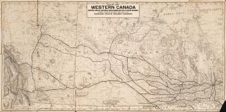
Map showing precise levelling by the Geodetic Survey of Canada
Date1915
Names
Canada. Department of the Interior
(author)
Government Printing Bureau
(printer)
FormatMap
Notes| Department of the Interior, Astronomical Branch. The map accompanies a report by F.B. Reid, D.L.S. which the library has in microfiche format: https://www.torontopubliclibrary.ca/detail.jsp?Entt=RDM2608394&R=2608394 |
Subject
Dimensions56.5 cm x 98 cm (22 1/4 in. x 38 9/16 in.)
Scale1 inch = 100 miles
Language
CollectionBaldwin Collection of Canadiana
Usage Rights
Public Domain
(Learn More)
Object Number912-71-C12-1

![[Plate 50. Key map for 1893 atlas] Atlas of the city of Toronto and vicinity from special survey founded on registered plans and showing all building and lot numbers.](/internal/media/dispatcher/1947661/thumbnail)
![[Plate 48. Key map for 1893 atlas] Atlas of the city of Toronto and vicinity from special survey founded on registered plans and showing all building and lot numbers.](/internal/media/dispatcher/2116661/thumbnail)
![[Plate 49. Key map for 1893 atlas] Atlas of the city of Toronto and vicinity from special survey founded on registered plans and showing all building and lot numbers.](/internal/media/dispatcher/2063019/thumbnail)
![[Key map for 1893 atlas] Atlas of the city of Toronto and vicinity from special survey founded on registered plans and showing all building and lot numbers.](/internal/media/dispatcher/2001255/thumbnail)
![[Plate 30] Toronto Island Map: Atlas of the city of Toronto and vicinity from special survey founded on registered plans and showing all building and lot numbers.](/internal/media/dispatcher/1947573/thumbnail)