

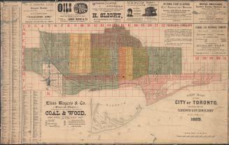
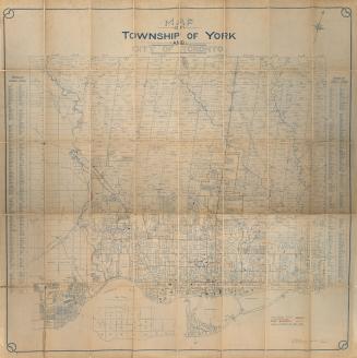
Map of the city of Toronto
Date1906
Names
Might Directories, Limited
(publisher)
Canada. Department of Agriculture
(contributor)
FormatMap
NotesIncludes street index and ward boundaries and street railways.
Subject
Dimensions77 cm x 100 cm (30 5/16 in. x 39 3/8 in.)
Scale1 mile = 5000 feet
Language
CollectionBaldwin Collection of Canadiana
Usage Rights
Public Domain
(Learn More)
Object NumberT-1906-LARGE
Robertson, J. Ross (John Ross), 1841-1918
1908

![[Plate 30] Toronto Island Map: Atlas of the city of Toronto and vicinity from special survey founded on registered plans and showing all building and lot numbers.](/internal/media/dispatcher/1947573/thumbnail)


![[Plate 50. Key map for 1893 atlas] Atlas of the city of Toronto and vicinity from special survey founded on registered plans and showing all building and lot numbers.](/internal/media/dispatcher/1947661/thumbnail)
![[Plate 48. Key map for 1893 atlas] Atlas of the city of Toronto and vicinity from special survey founded on registered plans and showing all building and lot numbers.](/internal/media/dispatcher/2116661/thumbnail)