

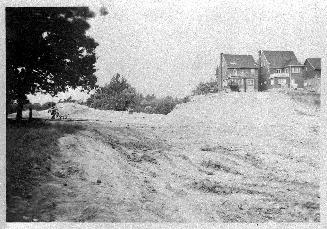
Mt. Pleasant Rd., aerial view looking north from south of Bloor Street East, during construction of Mt. Pleasant Road, Toronto, Ontario
Date1946
Names
Unknown
(author)
FormatPicture
NotesMT. PLEASANT RD., aerial view looking north from south of Bloor St. East, during construction of Mt. Pleasant Rd.
Subject
Medium
DimensionsUnknown
Language
CollectionBaldwin Collection of Canadiana
Usage Rights
Public Domain
(Learn More)
Object NumberPICTURES-R-2365

Salmon, James V. (James Victor)
1952

Boustead, James B.
1912 circa


Canadian Stereoscopic View Co.
1900
Singley, B. L. (Benjamin Lloyd)
1905
Salmon, James V. (James Victor)
1952