Might directories' 1920 Official street guide of the City of Ottawa with map and miscellaneous information
Date1920
Names
Might Directories, Limited
(publisher)
Unknown
(author)
FormatBook
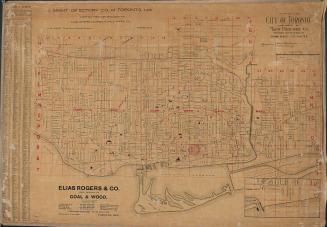
NotesMight directories' 1920 Official street guide of the City of Ottawa with map and miscellaneous information. Includes brief description of the city, alphabetical listing of streets, streetcar lines, schools, parks, public buildings, churches, hospitals, etc. Foldout map.
Subject
Medium
Dimensions64p. ; 15.3cm x 11.5 cm
Language
Usage Rights
Public Domain
(Learn More)
Object Number37131104743109D